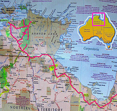
- Guide maps/routes
These kinds of maps are often found in tourist information brochures, are usually quite simple but quite zoomed in so that you can see where you are going. These will often cover a small area in a lot of detail so it is east for holidaymakers to find their way around. - County maps
Maps often cover a county, such as Yorkshire, or a smaller area, such as the area around a big city (e.g. Birmingham). These maps are made by a company called Ordinance Survey and are classified as outdoor leisure maps or land ranger maps. Outdoor leisure maps show you all the footpaths in an area, all the gradients and hills, as well as normal features such as roads, railway tracks and villages.
Land ranger maps are usually a bigger scale map, and have the same information, but more zoomed out to show a larger proportion of land. The scale of these such maps is usually an inch or two inches to represent a mile. By using this, you can measure how long a walk, cycle ride or other leisure activity will be. - World/country maps
These maps will be on a much larger scale and do not have as much detail. Often they will not include roads, only the names of towns, cities, hills and valleys. A country map will likely have more detail than a world map. The world map, being so vast, tends only to include the names of large cities. These maps are ideal for looking where you are going on holiday, or learning about other places in the world. You can also buy globes, which show you the earth in its actual rounded form. These are ideal for identifying where countries are in accordance with the equator and the poles.

There are basically six types of maps. Every map has a compass point showing the four basic directions, namely north, south, east and west. In addition, all maps are drawn to a scale. They are climate maps, economic or resource maps, physical maps, political maps, road maps and topographic maps.
Climate maps give information about climatic and precipitation conditions prevalent in a region. Precipitation includes rainfall and snowfall. Economic or resource maps feature the type of natural resources or economic activities that an area is known for. Physical maps show the physical features of an area, such as mountains and rivers. They usually use colours such as blue, green and orange to highlight the water bodies and elevations of mountains (typically green is used for low-lying areas and orange is used for higher altitudes).
Political maps show places and clearly indicate state and national boundaries. Capitals and major cities are highlighted appropriately. The common symbol used for national or state capitals is a star within a circle. Road maps show the major highways, railway tracks, airports and places of interest within a country, county, state, province or city. Topographic maps are maps which use contour lines to highlight the shape and elevation of an area. Closer contours mean a steeper terrain, and if the lines are far apart from each other, it indicates a flatter terrain.
1. Orographic or relief map
2. Climate Map
3 whether map
4. Vegetation map
5. Geological map
6. Biomedical map
There are over 10 different kinds of maps. I am only 13 years old and I might have more answers then you. But may I mention I go to a Jesuit Academy in Regina, Saskatchewan
1. County Maps
2. World/country maps
3.Orographic maps
4.Weather map
5.Biomedical map
6.Geological map
7.Climate map
8.Economic or resource maps
9.Physical maps
10.Political maps
11.Transportation maps
12.Road maps
13.Topographic maps
14.Thematic map
15.Guide maps
16.Elevation map
17.Projection map
18. Grid map.
1elevation map using contour lines
2. Projection map
2. Grid map